

Milton has rapidly strengthened into a Category 4 hurricane as it heads towards population centres in the US state of Florida, including Tampa and Orlando.
The hurricane threatens a dangerous storm surge in Tampa Bay and sets the stage for potential mass evacuations less than two weeks after the catastrophic Hurricane Helene swamped the coastline.
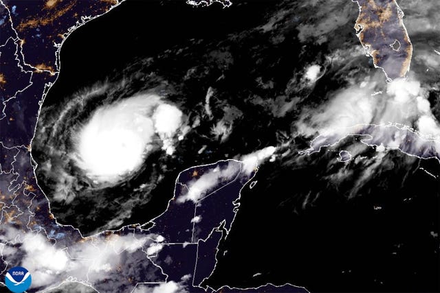
Milton had maximum sustained winds of 150mph over the southern Gulf of Mexico, the US National Hurricane Centre in Miami said.
The storm could make landfall on Wednesday in the Tampa Bay area and may remain a hurricane as it moves across central Florida towards the Atlantic Ocean.
That path would largely spare other south-eastern US states ravaged by Helene, which caused widespread damage from northern Florida to the Appalachian Mountains and killed at least 230 people.
Forecasters warned of a possible eight to 12-foot storm surge (2.4 to 3.6 metres) in Tampa Bay and said flash and river flooding could result from five to 10 inches (13 to 25cm) of rain in mainland Florida and the Keys, with as much as 15 inches (38cm) in places.
The Tampa Bay area is still cleaning up extensive damage from Helene and its powerful surge. Twelve people died, with the worst damage along a 20-mile string of barrier islands from St Petersburg to Clearwater.
Florida Governor Ron DeSantis said on Monday that it was imperative that messes from Helene be cleaned up ahead of Milton’s arrival so they do not become dangerous flying projectiles.
“We don’t have time for bureaucracy and red tape,” Mr DeSantis said. “We have to get the job done.”
Milton’s centre was about 150 miles (240km) west of Progreso, Mexico, and about 735 miles (1,185km) southwest of Tampa on Monday morning, moving east-southeast at 8mph (13kph), according to the hurricane centre.


Comments: Our rules
We want our comments to be a lively and valuable part of our community - a place where readers can debate and engage with the most important local issues. The ability to comment on our stories is a privilege, not a right, however, and that privilege may be withdrawn if it is abused or misused.
Please report any comments that break our rules.
Read the rules here